
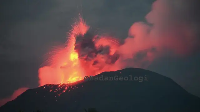
Bandung – The activity of Gunung Ibu in North Maluku has been declared to be increasing.The Geological Agency has raised the status of the volcano from Level III (Alert) to Level IV (Warning). The public is also urged not to engage in activities near the radius of the active crater.
“Based on the results of visual and instrumental monitoring indicating an increase in volcanic activity at Mount Ibu, the activity level of Mount Ibu has been raised from Level III (Alert) to Level IV (Warning) effective from January 15, 2025, at 10:00 WIT,” stated the Head of the Geological Agency, Muhammad Wafid, in a written report received in Bandung (January 15, 2024).
Mount Ibu was previously declared to be at Level III since June 21, 2024. At Level III activity, the eruption events reach an average of 70 occurrences per day. Until January 15, 2025, there were five eruption events with eruption columns that tended to be higher and larger than usual.

“Visually, the activity of Mount Ibu has increased.” From January 1-14, 2025, there were four eruptions with an eruption column height reaching 3,000 meters. On January 11, 2025, at 19:58 WIT and January 15, 2025, at 07:11 WIB, the height of the eruption column reached 4,000 meters from the summit crater,” he explained.
In connection with the Level IV activity of Mount Ibu, the Geological Agency has issued several recommendations as follows:
- The community around Mount Ibu and visitors/tourists are advised not to engage in activities, hike, or approach Mount Ibu within a radius of 5 km and a sectoral area of 6 km from the opening of the crater in the northern part of the active crater of Mount Ibu.
- If there is ash rain, people who are active outside the house are advised to use nose and mouth protection (mask) and eye protection (glasses).
- Residents located outside a 5 km radius and outside a 6 km sectoral area must increase their vigilance while continuing to follow the directives from the Local Government.
- The community around Mount Ibu is advised to be vigilant of the potential lahar in the rivers that originate from the peak of Mount Ibu, especially during heavy rain at the peak.
- The community around Mount Ibu is urged to remain calm and not be swayed by issues regarding the eruption of Mount Ibu, and to always follow the guidance of the North Maluku Provincial BPBD and the West Halmahera District BPBD or the Center for Volcanology and Geological Hazard Mitigation, Geological Agency in Bandung.
- The entire community, as well as local governments and other related institutions, can monitor the activity and recommendations of Gunung Ibu through the MAGMA Indonesia application, which can be downloaded from Google Playstore or through the websites https://magma.esdm.go.id, https://vsi.esdm.go.id, and the Geological Agency website https://geologi.esdm.go.id, as well as the PVMBG social media (Facebook, Instagram, and Twitter pvmbg).


Leave a Reply