
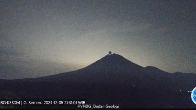
Lumajang – Mount Semeru, located on the border between Lumajang Regency and Malang Regency, has recorded several eruptions with eruption heights reaching 300 meters to 600 meters above the summit of the mountain on Thursday night (5/12/2024).
“An eruption of Mount Semeru occurred at 21:29 WIB with an eruption column height observed at around 600 meters above the summit or 4,276 meters above sea level,” said Liswanto, an officer at the Mount Semeru Observation Post, on Friday (6/12/2024).
He said the ash column was observed to be white to gray with moderate intensity towards the southwest. Previously, the Semeru Volcano eruption also occurred at 21:09 WIB with an eruption column height observed to be around 300 meters above the peak and the ash column observed to be white to gray with moderate intensity towards the southwest.
“When the report was made, the eruption was still ongoing. A previous eruption also occurred at 20:09 WIB with an observed column height of about 400 meters above the summit,” he said.
Based on the records of the officers, Mount Semeru experienced 11 eruptions on Thursday from 00:44 WIB to 21:29 WIB, but it is predicted that the eruptions will continue in line with the active status of the volcano or at the alert level.
The Center for Volcanology and Geological Hazard Mitigation (PVMBG) has issued several recommendations, including prohibiting the public from engaging in any activities in the southeastern sector, along the Besuk Kobokan, within eight kilometers from the eruption summit.
Prohibited Activities Within 500 Meters From the Riverbank

Furthermore, beyond that distance, the public is prohibited from engaging in activities within 500 meters from the riverbank along Besuk Kobokan, as it is at risk of being affected by the expansion of hot clouds and lahar flows up to 13 kilometers from the summit.
“The public is also prohibited from engaging in activities within a three-kilometer radius from the crater/summit of Mount Semeru, as it is prone to the danger of volcanic rock ejection,” said Liswanto.
In addition, the community needs to be wary of the potential for pyroclastic flows, lava flows, and rain-induced lahars along the river valleys that originate from the summit of Mount Semeru, especially along Besuk Kobokan, Besuk Bang, Besuk Kembar, and Besuk Sat, as well as the potential for lahars in the small rivers that are tributaries of Besuk Kobokan.


Leave a Reply